All distances are approximate. Some are rounded up, some are rounded down. The total distance is very close to 100 miles.
General Description
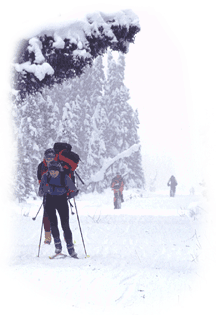 The current 100-mile course has evolved through changes in availability of checkpoint locations. Attached to this document is a link to a map that depicts the Susitna 100 course. The rivers and lakes that are named in this description can be oriented to the U.S. Geological Survey's Tyonek Quadrangle, should the truly curious want a clearer picture of what the course looks like in, say, mid-July. In February, however, this country is reduced to two colors, white and green, and is typically framed by a blue sky. Thanks to drifting snow, the region's shallow topography is barely distinguishable. This classic rendering of winter in simple colors and contours is marred only the intrusion of four-foot wide snow machine trails that run for miles across lakes and rivers and through breaks in the tree line. You are grateful for these trails, because they provide the foundation that makes human-powered travel faster than would otherwise be possible.
START
All Susitna 100 racers are required to check in at least 15 minutes before the start and declare a division. If some of your equipment did not pass inspection at the pre-race meeting, it will be checked after the 9:00AM start.
The race starts (and finishes) at Happy Trails Kennels mile 4.5 West Lakes Blvd, Big Lake Alaska. Allow two hours driving time from Anchorage.
Driving directions from Anchorage –
North on Hwy 1 (Glenn Highway), Hwy 1 turns into Hwy 3 (Parks Highway), go through Wasilla, turn left on Big Lake road at mile 52. Drive 3 ¼ miles on Big Lake Road, turn right on Beaver Lake Road, go 1 mile, turn left onto West Lakes Boulevard (long name, short sign "W.Lks.Blvd"). Approximately 4 ½ miles turn right at sign for Happy Trails Kennels.
HAPPY TRAILS KENNELS (HTK) TO AYRSHIRE RD
Heading straight ahead through this intersection the trail continues a couple more miles turning left for a short section then right again leading to the Little Su boat Launch. Across the Little Su and follow the boat launch road to the intersection with Ayrshire Road.
Follow along Ayrshire Rd staying on the left shoulder to the parking lot approximately 100 yards from the intersection.
Do not travel on the road! We do not have permits or insurance that allows travel on the road. You will be disqualified if you run, ride, or ski on the road!
If you race isn't going as planned at this point, this would be a good place to consider your options as this is the last road access point for many more miles!
AYRSHIRE RD TO FLATHORN LAKE
Approximately 5 more miles the trail enters the woods just prior to Flathorn Lake. A steep decent followed by a right hand turn leads you to the lake where the trail will take you to the far bank. Take care to stay off of the marked runways in this area. About ¼ mile up the shoreline you will find the Flat Horn Lake checkpoint in the red cabin beyond the silver house. This property is home of long-time race supporter Kirk Garoutte. Please respect their property and relieve yourself only in the outhouse.
FLAT HORN LAKE TO FIVE STAR CHECKPOINT
Leaving the checkpoint, the course takes a left at the bottom of the hill. Follow the lake around to the left along the large horn of Flathorn lake. After a couple of miles the trail leaves the lake to the right up a steep embankment following the historic Iditarod trail. The course takes you to the left at Barbie Doll corner, past the Nome sign. After crossing Big Lake trail 11 and traik 6 you will follow the Alfred Creek trail eventually crossing Fish Creek. After the creek crossing you will come out of the woods into an open swamp and the comfort of 5-Star checkpoint within the next mile or two.
5-STAR TENT TO WILLOW COMMUNITY CENTER (WCC)
WILLOW COMMUNITY CENTER (WCC) TO COW LAKE
COW LAKE TO HTK/FINISH
At the far end of Cow Lake the trail goes over a small hill to Little Cow Lake. Bearing left at the end of the lake you'll take the Cow trail #10 towards Butterfly Lake and Gunmetal Lake eventually turning right onto Trail #4.
At this intersection you will find the last checkpoint 8 miles from the finish. Follow Big Lake Trail #4 back to Gnome corner turning left towards HTK. Following more swamps and small lake eventually leading to Happy Trails Kennel and the finish!